Other Name(s)
Fortress of Louisbourg
Fortress of Louisbourg National Historic Site of Canada
Forteresse de Louisbourg
King's Bastion, Dauphin's Bastion, Louisbourg Lighthouse
Bastion du roi, Bastion du dauphine, Phare-de-Louisbourg
Links and documents
Construction Date(s)
1713/01/01
Listed on the Canadian Register:
2006/01/17
 Statement of Significance
Description of Historic Place
Fortress of Louisbourg is the largest reconstructed 18th-century French fortified town in North America, located on the southeast edge of Louisbourg Harbour adjacent to the Atlantic Ocean in southeastern Cape Breton, Nova Scotia. It is composed of the site of the original fortress as well as associated outlying lands and islands, and contains rare remnants of 18th-century French and British life in North America. Part of the fortress and town of Louisbourg has been reconstructed to assist visitors in understanding its scale, complexity and dimension. The designation refers to original surviving 18th-century elements of the landscape and built resources.
Heritage Value
Fortress of Louisbourg was designated a national historic site of Canada because:
- between 1713 and 1768 it was a place of profound significance in the great France-British struggle for empire.
The Fortress of Louisbourg was established by France as a critical fishing, trans-shipment and supply port for its maritime empire. As administrative capital of the French colonies of Ile Royale including Ile-St-Jean, it was home to the local government, an established military garrison and civilian population. It was also an important mercantile centre for French ships trading around the world and for development of a North American trading empire based on the fishery. As such, Louisbourg was a fortified town. It was a strategic base for protection of the lucrative French fishery and off-shore trade as well as guarding approaches to the Gulf of St. Lawrence, the main shipping route to Quebec and the North American interior. As a critical French asset, Louisbourg was a point of contention between French and British governments. It was besieged and captured by the British in 1745 and 1758. The British systematically demolished its fortifications in 1760-1768 and abandoned the town by the mid-1780s. Parks Canada has reconstructed approximately a quarter of the walled townsite (1961-81).
The heritage value of the Fortress of Louisbourg lies in its historical associations as illustrated by the surviving remnants of the 18th-century cultural landscape and the massive archaeological collection.
Sources: Historic Sites and Monuments Board of Canada, Minutes, 1920; Commemorative Integrity Statement, March 1997.
Character-Defining Elements
Key elements which contribute to the heritage value of the site include:
- its location on the Atlantic coast near fishing grounds and the entrance to the St. Lawrence River;
- its setting on a protected and relatively ice-free harbour;
- the complex and varied profile of the natural landscape which dictated the site development;
- the individual layouts and profiles of remnant and archaeological sites of functional areas such as siege works and encampments and the military design traditions they represent, their disposition and orientation in relation to one another and to geographic features;
- evidence of the roads and pathways that link them to each other and to the larger cultural landscape;
- the individual layouts and profiles of 18th-century remains found on evolved relict cultural landscapes such as the unreconstructed townsite, North Shore, Faubourg, lighthouse area, Rochefort Point, and the hinterland, the military and civilian design traditions they represent, the material and construction traditions they represent, their disposition and orientation in relation to one another, to geographic features, and to the larger landscape;
- the individual layouts and profiles of 18th-century remains within evolved continuing cultural landscapes such as cemeteries, roads and trails;
- the profiles and footprints of 18th-century graveyards and individual gravesites, their location, orientation and sanctity;
- evidence of 18th-century roads and trails throughout the larger cultural landscape, their composition, and their relationship to the pathways of roads visible today such as the “Old French Road”, Route 22, and sections of the Kennington Cove Road;
- archaeological resources located in all of these cultural landscapes, both above and below ground, both identified and unidentified, including those on the reconstructed townsite, those on outlying properties, those associated with outlying defensive works and battlefields, and those underwater in ponds, lakes and streams within the site and any others in the larger landscape of the fortress, the layout and profile of these archaeological resources, their materials and composition, their orientation, and spatial relationship to one another;
- 18th-century archaeological resources excavated from the site;
- viewscapes between and among smaller cultural landscapes within the site, and between the site and the water.
 Recognition
Jurisdiction
Federal
Recognition Authority
Government of Canada
Recognition Statute
Historic Sites and Monuments Act
Recognition Type
National Historic Site of Canada
Recognition Date
1920/01/30
Historical Information
Significant Date(s)
1713/01/01 to 1768/01/01
Theme - Category and Type
- Developing Economies
- Trade and Commerce
- Peopling the Land
- Settlement
- Governing Canada
- Military and Defence
Function - Category and Type
Current
- Leisure
- Museum
Historic
- Defence
- Military Defence Installation
Architect / Designer
n/a
Builder
n/a
Additional Information
Location of Supporting Documentation
Indigenous Affairs and Cultural Heritage Directorate Documentation Centre 3rd Floor, room 366 30 Victoria Street Gatineau, Québec J8X 0B3
Cross-Reference to Collection
Fed/Prov/Terr Identifier
303
Status
Published
Related Places
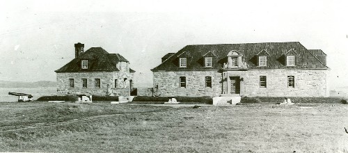
Museum and Caretaker's House
Situated within the picturesque setting of the Fortress of Louisbourg National Historic Site of Canada, the Museum and Caretaker’s House are both sandstone-faced…
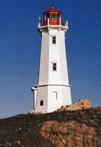
Tower
The Tower at Louisbourg is situated on a rugged site at the north side of the entrance to Louisbourg Harbour. The octagonal tower is a tapered, reinforced concrete structure built…