Other Name(s)
n/a
Links and documents
n/a
Construction Date(s)
1929/01/01 to 1929/12/31
Listed on the Canadian Register:
2016/12/21
 Statement of Significance
Description of Historic Place
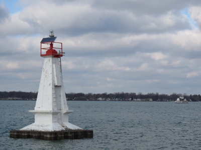
Walpole Island Upper A34 is a square-tapered, reinforced-concrete lighthouse with no lantern. It is located in the South Channel of the St. Clair River in Ontario, adjacent to Walpole Island. It is one of a series of lighthouses built for international shipping traffic travelling along the South Channel.
Heritage Value
The Walpole Island Upper A34 Lighthouse is a heritage lighthouse because of its historical, architectural, and community values.
Historical values
Walpole Island Upper A34 is a very good example of the square-tapered, lanternless navigational aids established in the early 20th century along the St. Clair River. The Upper A34 and Lower A32 aids to navigation were established as a pair in 1920. The original pole lights were replaced with reinforced concrete structures prior to a major dredging operation to further deepen and widen this international shipping channel in the mid-1930s.
Walpole Island Upper A34 is strongly associated with the international through-traffic traversing the St. Clair River between Lake Huron and Lake St. Clair, serving as a navigational aid. It is also associated with the Walpole Island First Nation community.
Architectural values
Walpole Island Upper A34 is a very good example of a well-detailed and proportioned square-tapered, reinforced-concrete lanternless tower. It stands approximately 5.4 metres (17.7 feet) tall and features a projecting sill and shallow inset panels that add a degree of elegance and visual interest to the tower.
The functionality of Walpole Island Upper A34 is very good. It was built using construction methods and materials that were typical of its time.
Community values
Walpole Island Upper A34 reinforces the character of the surrounding area. While it is located offshore, it is closely associated to a number of key community facilities on Walpole Island.
Walpole Island Upper A34 is a valued aid to the navigation in the area, and has the opportunity to be seen by large numbers of people in the boating and shipping communities.
Character-Defining Elements
The following character-defining elements of Walpole Island Upper A34 should be respected:
- its location offshore in the South Channel of the St. Clair River in Ontario, adjacent to Walpole Island;
- its intact, as-built structural form, height, profile and balanced proportions based on the standard design of square-tapered, reinforced-concrete towers;
- its tower elevations articulated with shallow inset panels;
- its straight cornice that supports the gallery;
- its reinforced concrete base consisting of a projecting sill, which rests on a raised, square, straight-sided foundation;
- its flashing beacon atop the tower;
- its metal rungs mounted on the exterior of the shaft and its plain metal door;
- its traditional red and white colour scheme, consisting of a white tower and red accents;
- its visual prominence in relation to the water and shorelines.
 Recognition
Jurisdiction
Federal
Recognition Authority
Government of Canada
Recognition Statute
Heritage Lighthouse Protection Act
Recognition Type
Heritage Lighthouse
Recognition Date
2015/05/29
Historical Information
Significant Date(s)
n/a
Theme - Category and Type
- Developing Economies
- Communications and Transportation
Function - Category and Type
Current
- Transport-Water
- Navigational Aid or Lighthouse
Historic
Architect / Designer
n/a
Builder
n/a
Additional Information
Location of Supporting Documentation
Heritage Conservation and Commemoration Directorate Documentation Centre
3rd Floor, room 366
30 Victoria Street
Gatineau, Quebec J8X 0B3
Cross-Reference to Collection
Fed/Prov/Terr Identifier
14833
Status
Published
Related Places
Walpole Island Lower A32 Lighthouse
Walpole Island Lower A32 is a square-tapered, reinforced-concrete lighthouse with no lantern. It is located in the South Channel of the St. Clair River in Ontario, adjacent to…