Other Name(s)
Sault Ste. Marie Canal
Canal de Sault Ste. Marie
Sault Ste. Marie Ship Canal
Sault Ste. Marie Canal National Historic Site of Canada
Canal de Sault Ste. Marie
Links and documents
Construction Date(s)
1894/01/01 to 1895/01/01
Listed on the Canadian Register:
2008/02/28
 Statement of Significance
Description of Historic Place
Sault Ste. Marie Canal National Historic Site of Canada is a man-made waterway that passes between the city of Sault Ste. Marie and Whitefish Island on the shipping channel joining Lake Huron and Lake Superior at Sault Ste. Marie, Ontario. Of particular note are the canal’s Powerhouse built into the slope of the hill at the downstream end of the lock, and the Emergency Swing Dam located west of the original lock near the Superintendent’s Residence. The canal is now operated as a recreational facility.
Heritage Value
Sault Ste. Marie Canal was designated a national historic site of Canada, in 1987, because:
- it is part of Canada’s national canal system,
- the Powerhouse, the Powerhouse machinery and the Emergency Swing Dam are resources of national historic and architectural significance.
The heritage value of the Sault Ste. Marie Canal lies in the legibility and completeness of the man-made waterway including its engineering works, associated buildings and designed landscape features. The Sault Ste. Marie Canal was completed in 1895 as part of Canada’s national canal system. The Powerhouse for the canal was built in 1894 during the initial phase of construction, and the canal’s Emergency Swing Dam was built by Dominion Bridge Co. in 1895. Administration of the Sault Ste. Marie Canal was transferred to the St. Lawrence Seaway Authority (1959-1979), then to Parks Canada to continue canal operation as a recreational facility.
Sources: Historic Sites and Monuments Board of Canada, 1987 Minutes; Commemorative Integrity Statement, 22 June 1999.
Character-Defining Elements
Aspects of this site which contribute to its heritage values include:
- the legibility of the canal corridor;
- the integrity of the canal path;
- the functional inter-relationship and orientation of facilities in the canal corridor;
- the engineering works, buildings and designed landscape features, particularly their massing, form, technologies and construction materials, and spatial relationships to one another;
- the rectangular massing of the Powerhouse under a hipped roof, its classical definition and form, the integrity of its red sandstone material and limestone details, the functional spaces of the interior of the building, the surviving equipment and engineering works associated with hydro-electric generation, canal operations and maintenance, its location at the north-east corner of the lock, its siting built into a slope at the end of the lock;
- the Emergency Swing Dam in its location, original form, fabric and functional design;
- viewplanes from the canal bed to Lake Superior, from the main shipping channel to Lake Huron, and the industrial facilities along the canal banks.
 Recognition
Jurisdiction
Federal
Recognition Authority
Government of Canada
Recognition Statute
Historic Sites and Monuments Act
Recognition Type
National Historic Site of Canada
Recognition Date
1987/11/20
Historical Information
Significant Date(s)
1895/01/01 to 1979/01/01
Theme - Category and Type
- Developing Economies
- Technology and Engineering
- Developing Economies
- Communications and Transportation
- Developing Economies
- Labour
Function - Category and Type
Current
Historic
- Transport-Water
- Canal or Canal Works
Architect / Designer
n/a
Builder
n/a
Additional Information
Location of Supporting Documentation
National Historic Sites Directorate, Documentation Centre, 5th Floor, Room 89, 25 Eddy Street, Gatineau, Quebec
Cross-Reference to Collection
Fed/Prov/Terr Identifier
509
Status
Published
Related Places

Workshop
The Workshop is set amongst a group of buildings located on St. Mary’s Island, which is bisected by the Sault Ste. Marie Canal. The two-storey, stone building has a gable roof,…
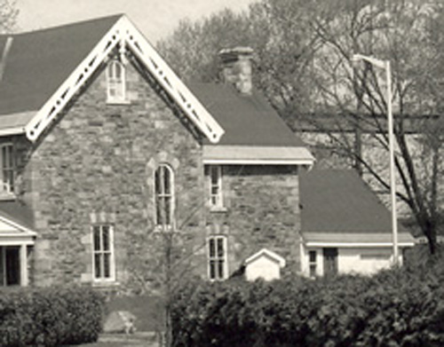
Superintendent's House
The Superintendent’s House is set amongst a group of buildings located on St. Mary’s Island, which is bisected by the Sault Ste. Marie Canal. The two-and-a-half-storey stone…